Balcerzak Drive Corridor Study
 The Mankato/North Mankato Area Planning Organization (MAPO) is launching a comprehensive study of Balcerzak Drive aimed at transforming the corridor to be safer, more efficient, and more accessible. This study will use MAPO’s corridor planning process, leveraging previous evaluations, stakeholder input, and public engagement. The outcome will create a guiding vision for the future, ensuring Balcerzak Drive meets the diverse needs of motorists, pedestrians, bicyclists and transit users while aligning transportation goals. The study is expected to be completed in December 2025.
Considering that the City of Mankato is a primary MAPO partner, City resources such as Every Voice Mankato are shared to engage the public and achieve the best outcomes possible.
Study Focus:
- Address current transportation challenges
- Enhance multimodal connectivity
- Plan for future growth and development
What will the study include?
Comprehensive Analysis: An in-depth review of existing conditions, such as traffic patterns, safety concerns, and the current state of pedestrian and bicycle infrastructure.
Alternatives Development: Exploration and evaluation of various improvement scenarios, including changes to lane configurations, intersection controls, and access management.
Multimodal Enhancements: Recommendations for improving pedestrian and bicycle facilities, ensuring safe and convenient access for all users.
Transit Improvements: Assessment and enhancement of transit stops and services along the corridor to better serve the community.
Implementation Plan: A prioritized list of projects with potential funding sources, guiding the transition from planning to execution.
- Policy Alignment: Ensuring that the recommendations align with local, state, and federal policies and plans, including the integration with the City's broader transportation and land use strategies.
Get involved:
There are multiple opportunities for you to provide input on the future of Balcerzak Drive:
- Take a survey
- Attend an open house or meeting
- Join a pop-up event (watch for updates on where we are popping up next!).
- - - - - - - - - - - - - - - - - - - - - - -
Past Events:
Open House: Tuesday, Sept. 30
Time: 4-6:30 p.m.
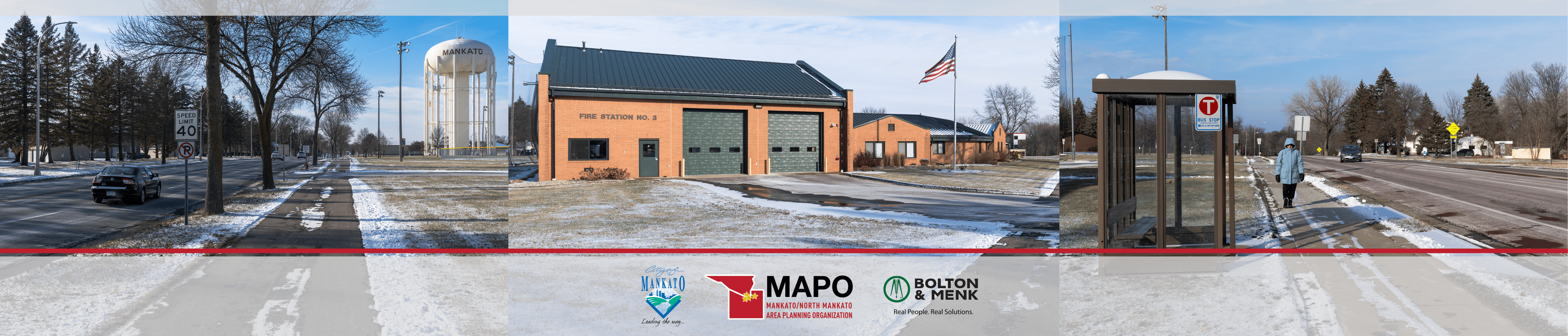
Location: Mankato Fire Station #3 | 1230 Pohl Rd. | Mankato, MN 56001
Help shape the future of Balcerzak Drive! Join us for an open house on Tuesday, Sept. 30 from 4-6:30 p.m. at Fire Station #3 (1230 Pohl Rd, Mankato, MN 56001).
Review concept designs and share your feedback on potential improvements to Balcerzak Drive between Warren Street and Victory Drive. Whether you drive, walk, bike, or ride the bus, your input matters.
- View boards from open house.
- Take the survey (open until Oct. 14)
- - - - - - - - - - - - - - - - - - - - - - -
Virtual Meeting: Thursday, May 29, 6 p.m. (RECORDING AVAILABLE)
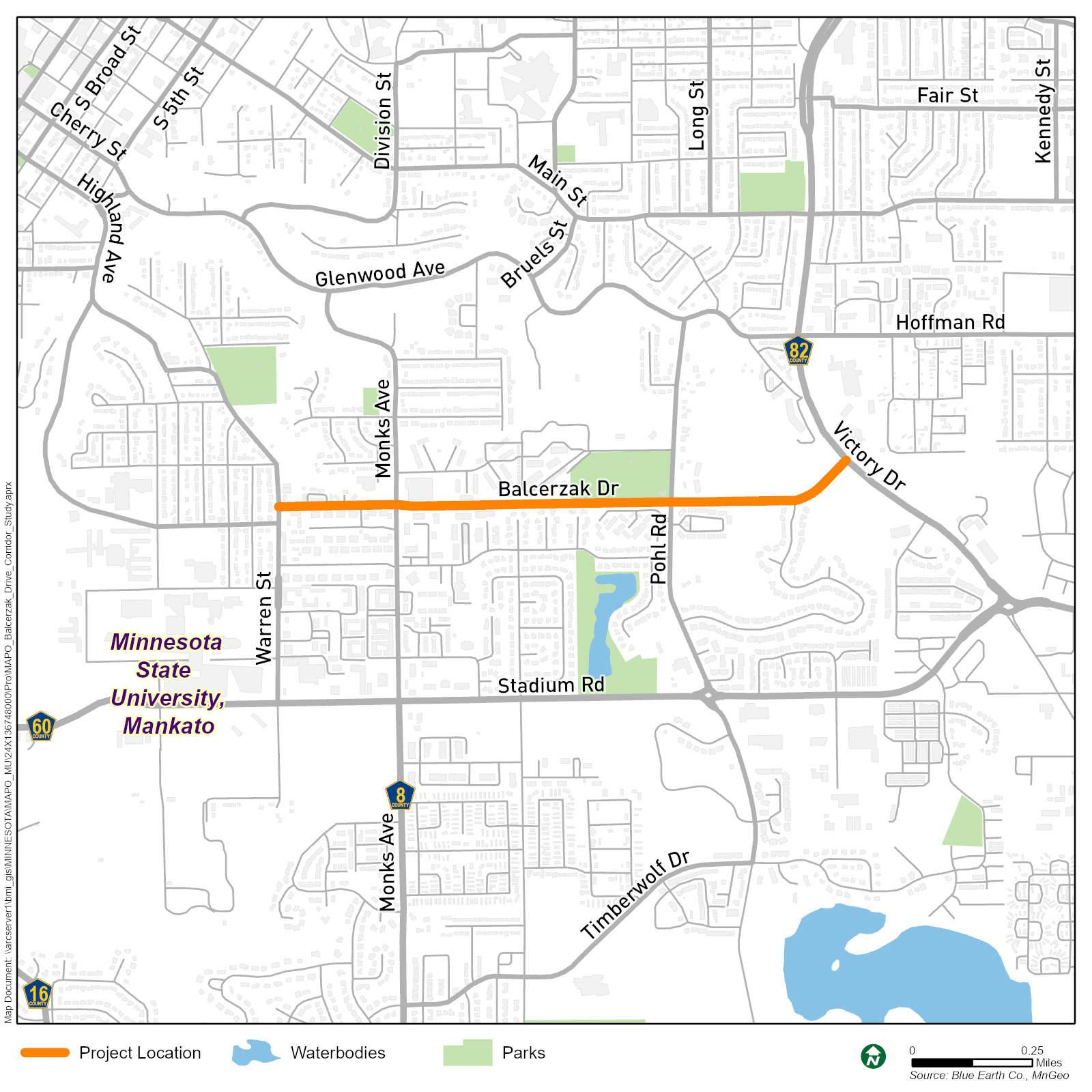
Balcerzak Drive Background
Balcerzak Drive is one of four east-west minor arterials* serving the Mankato Hilltop area. It connects other significant minor arterials, including Warren Street and Victory Drive/Highway 82. Currently, Balcerzak Drive operates as a four-lane undivided corridor with a daily traffic volume of approximately 8,100-8,700 vehicles and a posted speed limit of 40 mph.
There are also multiple transit routes in the area:
- Routes 1, 8, 14, between Warren Street and Monks Avenue
- Routes 10, 11, between Monks Avenue and Victory Drive
The corridor has undergone incremental changes over time, such as lane narrowing at both the Warren Street and Victory Drive intersections. Additionally, the Balcerzak/Pohl Road intersection was studied in 2016. A roundabout was recommended at that time as a potential improvement.
*Arterial - A major road designed to carry high volumes of traffic, connecting different areas of a city or region, often with multiple lanes and intersections with signals.
What is MAPO?
 The Mankato/North Mankato Area Planning Organization (MAPO) is responsible for regional transportation planning throughout the Greater Mankato area. This includes pedestrian, bicycle, transit, auto, rail, and air transportation. The organization was established in 2012 following the 2010 Census that designated the region as an urbanized area, requiring the formation of such a planning organization.
MAPO continually produces a wide range of studies, plans, and recommendations to improve transportation throughout the area. The organization is located at the Intergovernmental Center, 10 Civic Center Plaza, Mankato and is staffed by executive director Mark Konz and transportation planner Chris Talamantez.
Which government entities are included in MAPO?
| Cities | Counties | Townships |
|---|---|---|
|
|
|
-
Design Concepts
Share Design Concepts on Facebook Share Design Concepts on X (formerly Twitter) Share Design Concepts on Linkedin Email Design Concepts link
 Review concept designs and share your feedback on potential improvements to Balcerzak Drive between Warren Street and Victory Drive. Whether you drive, walk, bike or ride the bus, your input matters. Survey will be available from Sept. 30 to Oct. 14.
 -
Open House: Sept. 30, 4-6:30 p.m.
Share Open House: Sept. 30, 4-6:30 p.m. on Facebook Share Open House: Sept. 30, 4-6:30 p.m. on X (formerly Twitter) Share Open House: Sept. 30, 4-6:30 p.m. on Linkedin Email Open House: Sept. 30, 4-6:30 p.m. link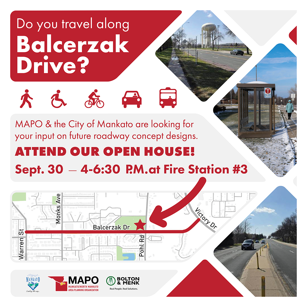
 Open House: Tuesday, Sept. 30, 4-6:30 p.m.
Time: 4-6:30 p.m.
Location: Mankato Fire Station #3 | 1230 Pohl Rd. | Mankato, MN 56001Help shape the future of Balcerzak Drive! Join us for an open house on Tuesday, Sept. 30 from 4-6:30 p.m. at Fire Station #3 (1230 Pohl Rd, Mankato, MN 56001).
Review concept designs and share your feedback on potential improvements to Balcerzak Drive between Warren Street and Victory Drive. Whether you drive, walk, bike, or ride the bus, your input matters.
-
Online Meeting: May 29, 6 p.m.
Share Online Meeting: May 29, 6 p.m. on Facebook Share Online Meeting: May 29, 6 p.m. on X (formerly Twitter) Share Online Meeting: May 29, 6 p.m. on Linkedin Email Online Meeting: May 29, 6 p.m. link
 The City of Mankato and the Mankato/North Mankato Area Planning Organization (MAPO) invite you to attend an online public meeting for the Balcerzak Drive Corridor Study on Thursday, May 29 at 6 p.m.
 During this virtual event, you'll have the opportunity to learn more about the study, share your thoughts about the future of Balcerzak Drive, and ask the project team questions about the study.
The study focuses on improving safety, efficiency, and accessibility for everyone who uses the corridor, whether by car, foot, bike, or bus. We’re currently gathering community input to better understand how the corridor functions and what changes could make it work better for everyone.
If you are unable to attend the meeting, you can still participate by taking the online survey. The survey will remain open through June 8.
Share Your Thoughts

Review concept designs and share your feedback on potential improvements to Balcerzak Drive between Warren Street and Victory Drive. Whether you drive, walk, bike, or ride the bus, your input matters.

Meeting Recordings
-
Watch the recording of the virtual meeting for the Balcerzak Drive Corridor Study held on Thursday, May 29. Learn about the study, hear community feedback, and see the project team address questions about the corridor's future.
Project Location
Who's Listening
-
Transportation Planner
Mankato/North Mankato Area Planning Organization

Phone 507-387-8389 Email ctalamantez@mankatomn.gov -

Phone 507-387-8611 Email mkonz@mankatomn.gov -

Email kkeel@mankatomn.gov -

Email pdavid@mankatomn.gov -